
History of the High Trestle Trail
When I let my friend Kim know that my husband and I would be traveling through Iowa and would love to stop by for a visit, she and I both understood that a visit would indeed have to include a bike ride together. I let Kim do the planning and she didn’t disappoint when she proposed an out-and-back ride along the High Trestle Trail.
The High Trestle Trail is a 25-mile long rail trail running along the old Union Pacific Railroad corridor which was completed in segments, with the final section being the High Trestle Trail Bridge. The two paved sections from Ankeny to Woodward were completed in 2008, but the entire length of the trail couldn’t be enjoyed until the bridge across the Des Moines River joining the two segments was completed in 2011. Reaching almost a half mile long and 13 stories high, the High Trestle Trail Bridge’s unique architectural design has won its designers many awards and is the highlight of the trail.
About the Trail
From Ankeny to Woodward, the entire trail spans 25 miles one way. Our ride started in Slater, cutting the distance in half. With only 341 feet of climbing over 26 miles roundtrip, the trail is mostly flat. A gradual 1%’ish grade leading from the bridge to the turn-around in Woodward was noticeable, but not enough to make it difficult. Paved, it was a combination of mostly concrete and some asphalt with the occasional side trail splitting off. Most sections were in full sun while a few areas took us under a canopy of trees. The trail wasn’t overly crowded which allowed us the ability to ride side-by-side and chat as we rode.
While we didn’t use a Ride with GPS route, I’ve included one very similar to what we rode (see below).
Ride Overview
- • Ride Name: High Trestle Trail Slater-Woodward OAB 27m 600f
- • Ride with GPS: Link to turn-by-turn navigation cue sheet
- • Location: High Trestle Trail
- • Start/Finish: Southside Park, Slater, Iowa
- • Course Type: out and back
- • Course Surface: paved
- • Bike: Salsa Warbird
- • Distance: 26.51 miles
- • Time: 1:55:29
- • Average Speed: 13.8 MPH
- • Maximum Speed: 24.6 MPH
- • Elevation Gain: 341 feet
- • Elevation Range: 944 to 1,067 feet
- • Weather: 79° and sunny, climbing to 84° (feels like 90°)
- • Date of ride: July 27, 2024
- • Course Map:

Fun Pictures From Along the Way
Most of the following pictures were taken with my iPhone; however, a special shoutout goes to my husband who captured some of the fun with his Insta360.
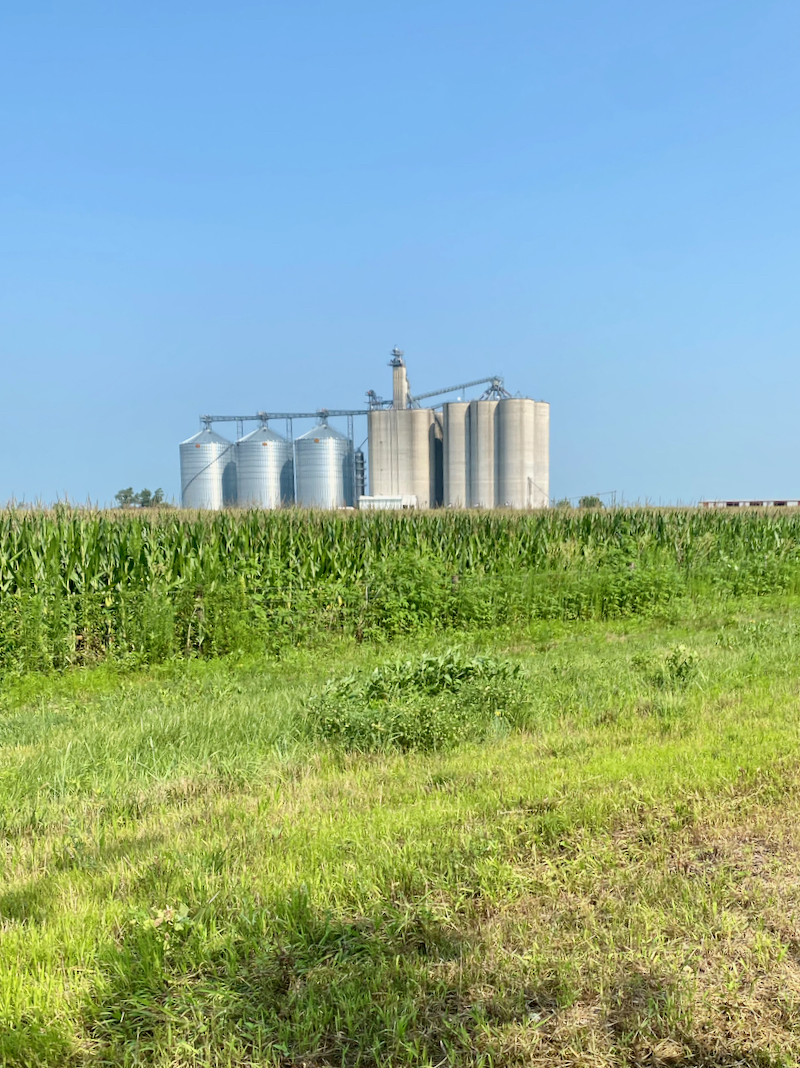
Soon after starting, I whipped out my phone when we rode past a slew of silos situated near a cornfield. The vastness of the cornfields and huge number of silos impressed this farm girl.

I loved the openness of the trail.


When we stopped in Madrid to use the restrooms and refill our water bottles, we took time to pose for some silly pictures.


Ten miles into our ride, we reached the High Trestle Trail Bridge…


A half mile later we were on the west side of the Des Moines River where we started a very gradual 1% climb to our turnaround.

Once at the Woodward Trailhead, we rested and refueled for about 20 minutes before making our way back to the bridge for more pictures.

More silos near the turnaround…


We stopped at the High Trestle Trail Bridge overlook for pictures…


Back on the bridge heading home…

View from the bridge looking the south…

View from the bridge looking north…

I couldn’t get enough of the wide open and flat green cornfields…

Near the end of our ride, we stopped at the Nite Hawk Bar & Grill for lunch. Even though the building wasn’t air conditioned, the huge fans felt great and brought welcome relief after being out in the hot sun and high humidity.

Before leaving, Kim and Herky the Hawk fist bumped for good luck for a winning football season.

Outside the bar there was a sign welcoming trail users to refill their water bottles. It’s too bad that I didn’t have a VeloPigs sticker to add to the other bike club stickers on the sign…

Back at the parking lot, Kim and I posed for a final picture before saying our goodbyes so my husband and I could take off on the next leg of our road trip.

Garmin Stats
Post-ride Garmin…

Garmin map and elevation graph…


Final Thoughts on the Ride
This was such a fun ride, especially since it gave Kim and me additional time to catch up. The weather was very cooperative blessing us with a beautiful sunny day, albeit hot and humid, but that’s to be expected in Iowa in July. I loved the scenery: wide open cornfields, multiple silos and granaries, huge tractors, and assorted farm equipment (my farm girl heart was swelling by the time we finished). Crossing the Des Moines River on the High Trestle Trail Bridge was the icing on the cake!
Questions:
- • Have you been to Iowa? ~ This was my first visit.
- • Do you have a favorite trail that you’d take an out of town friend for a run or bike ride on? ~ We have the W&OD Trail nearby which I took Kim for a run on when she visited a few years ago.
- • Do you stop and relax occasionally to fuel or take pictures, or barrel on through when on a long run or ride? ~ Pictures, always pictures, unless I’m racing!
Disclaimer: This post contains affiliate links which means if you click on the blue product link and then make a purchase, I will receive a small commission for referring you. You will pay no more or less for the product; however, Amazon will show their gratitude for my referral by paying me.
Such wide open fields and so FLAT!! Amazing!
Garmin’s elevation graphs look deceivingly hilly if you don’t look at the actual numbers in the y-axis of the graph.
So nice to see you and Kim enjoying the bike ride together. Isn’t it nice to meet bloggers in real life?
Yes, I kind of cracked up when I saw the elevation graph on Garmin. It looked a lot more realistic on Strava than either Ride with GPS or Garmin.
You know Kim and I were happy to get to ride together in person. 🙂
I have never been to Iowa, but it’s on my list!
When people come here, I usually take them to downtown St. Augustine or the beach to run. We are not a bike-friendly area (or state, really), so that would be off the table. We do have two rail trails up here that are doable (just long stretches of pavement not open to cars with just a few intersections along the way), but they aren’t super fun.
What an amazing adventure!
We’ve done two big bike rides in Florida and loved both. Our first ride was from North Key Largo to Key West and that was an amazing experience! Our second trip was riding across the state from Cape Canaveral to St. Petersburg. That was fun, but we picked a cold week. We’re probably going back down to ride in the Miami area in January. 🙂
I love that you 2 had the chance to do this ride together.! I’ve never been to Iowa but who knows? Maybe I will find myself there one day.
It was so fun! As you know, it’s always nice to meet up with friends when traveling.
What a beautiful and fun ride! If you come to Illinois, we can get something to eat. Or we can run. We can do both. 🙂
That would be nice. When our son got his MBA at the University of Chicago we visited him and our daughter-in-law many times. I don’t think you and I had met through our blogs yet, though.
What a fun and scenic trip… I went to Iowa years and year ago for a conference. Didn’t see much.
How cool that you could combine this trip with seeing Kim IRL.
Pictures Pictures. Always.
It was fun! And yes, I love taking pictures, too!
I’m SO glad we were able to connect on your extended trip! The High Trestle Trail (especially the bridge!) is such a thing of beauty and grandeur. We need to make this (or a ride, somewhere) an annual must-do 🙂
Thanks for being our tour guide! “An annual must-do” – I like the sound of that!
Sounds like a wonderful and relaxing ride along the trail! The flat terrain and manageable grade make it accessible for riders of various levels, and the mix of sun and shaded sections likely added to the experience. Love that the trail wasn’t crowded, giving you the freedom to enjoy the scenery and have a good conversation along the way. It seems like a perfect route for a leisurely ride and an opportunity to connect with nature and companions!
It’s a great trail!
Enjoyed the article and all the great quality photos to “paint the picture” along the way!
Thanks!
I was involved with the concrete work in various parts of the trail. Nice to see folks are getting great use out of it!
Very cool!